
Los mejores Senderos de senderismo en Virginia
Explorar Senderos de senderismoLos 44 senderos de senderismo más populares en Virginia
Page 1 of 3
1


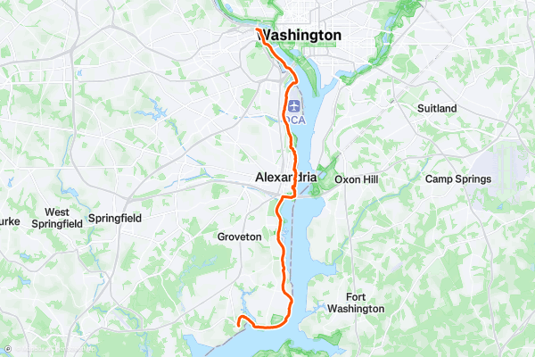
Mount Vernon Trail
The Mount Vernon Trail is a lengthy paved greenway trail running through the Washington DC metro area. This trail is extremely popular with road cyclists (both recreationally and for commuting), but walkers/hikers, runners, skaters, and more all use this trail....
2
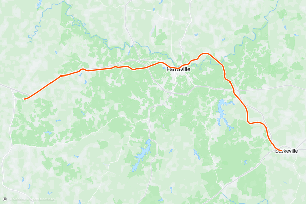
High Bridge Trail
The High Bridge Trail is a long-distance rails-to-trails route located between Lynchburg and Richmond, Virginia—although it doesn't reach either city. (The trail does run through the smaller town of Farmville.)
This trail is popular with cyclists, but walkers/hikers, runners, and equestrians all use this trail....
3


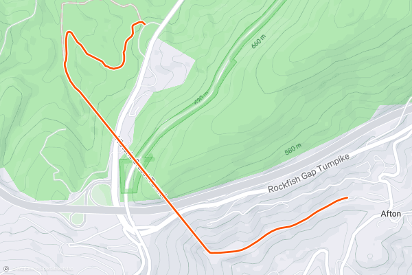
Blue Ridge Tunnel: Out-and-Back
If you are looking for a short but memorable hike or ride near Afton, Virginia, you might want to check out the Blue Ridge Tunnel Trail. This 4.6-mile out-and-back trail takes you through a 4,700-foot tunnel that was bored through the Blue Ridge Mountains in the 1850s....
4

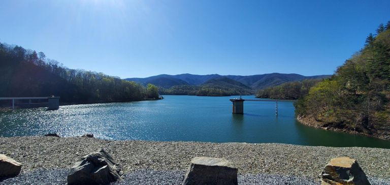


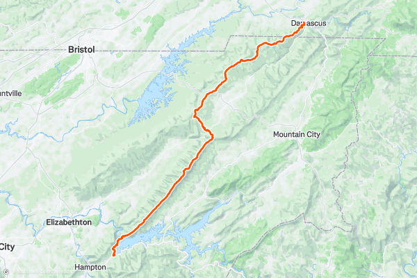
Appalachian Trail: Watauga Lake to Damascus
This stretch of the white blazed AT between Watauga Lake and Damascus is a relatively mild finish to its traverse through Tennessee.
The southern terminus of Watuaga Lake (US-321) is reported to by others to be a safe place to leave a vehicle if you are planning a point-to-point hike....
5


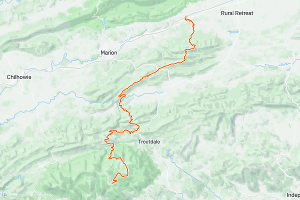
Appalachian Trail: Massie Gap to I-81
The southern terminus for this segment, Massey Gap, lies within Grayson Highlands State Park. Established in 1965, this region is home to countless outdoor activities including hiking, mountain biking, and horseback riding....
6


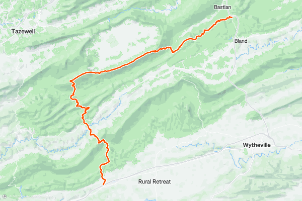
Appalachian Trail: I-81 to I-77
Heading north out of Atkins, VA, pass under Interstate 81 and look for the trail to the right after the service road. The trail winds through a few fields before entering back into the "green tunnel....
7


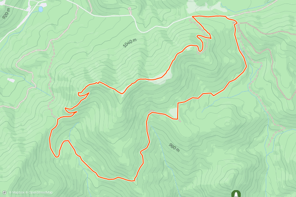
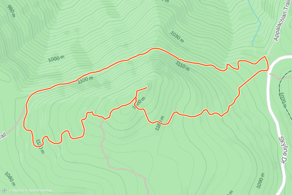
Cole Mountain Loop
Cole Mountain is arguably one of the most underrated spots on the AT in Virginia. As the 2,200-mile long Appalachian Trail leaves the comfort of the Blue Ridge Parkway, it spirals around Lynchburg Reservoir, crosses the Lexington Turnpike, then begins a demanding climb into remote high country....
8


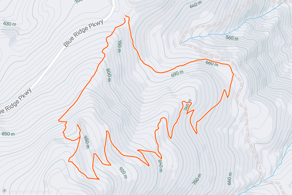
Humpback Rocks Loop
The Humpback Rocks Loop is an excellent family-friendly hike along the Blue Ridge Parkway. Hikers have the option for a shorter 2-mile out-and-back hike to the overlook or this 4-mile loop paired with a small portion of the 2,200-mile long Appalachian Trail....
9


Whiteoak Canyon -> Cedar Run Loop
White Oak Canyon is one of the most talked-about hikes in all of Shenandoah National Park. This circuit includes six waterfalls "ranging from 35 to 86 feet and many smaller cascades along the Whiteoak Canyon Trail," according to the NPS....
10


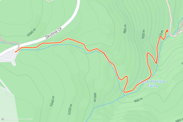
Dark Hollow Falls
Dark Hollow Falls is *the* must-do waterfall hike in Shenandoah National Park. It's less than 0.75 miles from the trailhead and is even accessible from Big Meadows Campground. Though challenging at times, your reward is a "beautiful series of waterfalls and cascades," on what the NPS highlights as "one of the most popular hikes in the park....
11


Hawksbill Mountain Loop
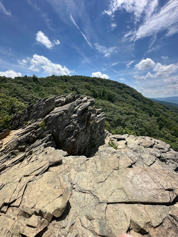
Towering in at 4,050', Hawksbill Mountain is the highest peak anywhere in Shenandoah National Park. In addition to the stunning views, the summit is home to balsam fir, a tree typically only seen in the northern latitudes - especially in New England and Canada....
12


Rose River Loop
The Rose River Loop is a classic day hike near Big Meadows Campground with stunning waterfalls, an abandoned copper mine, and a historic cemetery. It can be hiked in either direction, and an optional detour leads to Dark Hollow Falls, just 0....
13


South River Falls
South River Falls is a stunning 83' waterfall, and the 3rd largest in Shenandoah National Park [[source](https://www.hikingupward.com/SNP/SouthRiverFalls/)]. The South River Falls Trail is the shortest route to view the stunning 80'+ waterfall, just 1....
14


Dickey Ridge Loop
If you find yourself at the northernmost end of Skyline Drive, be sure to add this ~5-mile loop to your to-do list. A moderate hike to most, it passes a historic cemetery and the remnants of Snead Farm, then offers sweeping views from Dickey Hill at its furthest point....
15


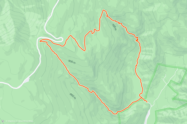
Riprap Hollow
This is one of the best one-night circuits in the southern district of Shenandoah National Park. There are multiple stream crossings, a small waterfall, and stunning views along Riprap Trail. This hike is a perfect option for anyone new to backpacking, but looking for a challenge....
16


White Rocks -> Hazel Falls Loop
This is an excellent one-night circuit with a small cave and waterfall. It could also be hiked in a single day, with the waterfall as the perfect lunch destination. Several rock surfaces overlook the waterfall below, allowing you to relax with a view....
17
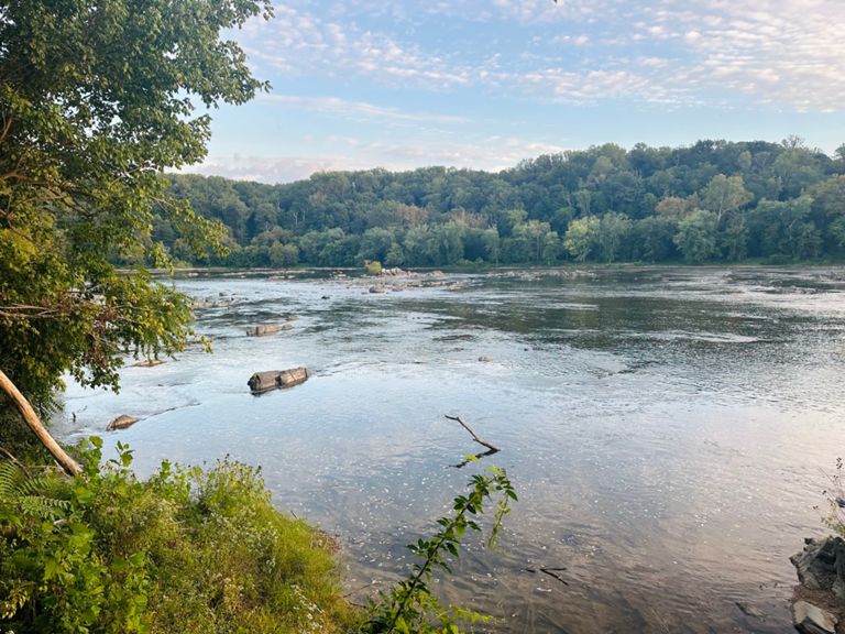


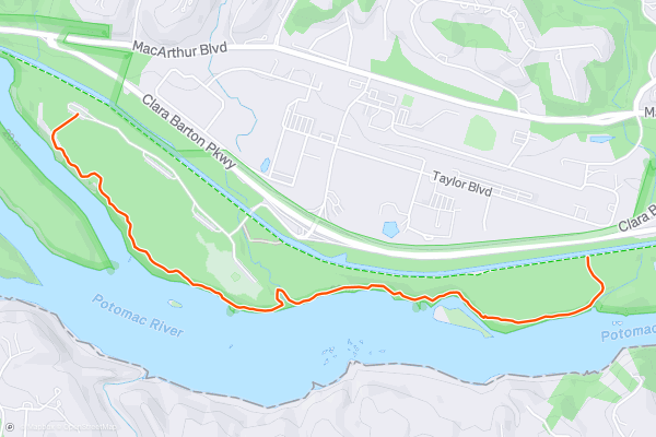
Billy Goat Trail Section C
The Billy Goat Trail is a popular hike along the Potomac River and Mather Gorge. From this stretch of trail, you can view the Lower Mather Gorge, including Stubblefield Falls.
At one point, the trail runs along the top of a cliff band that is popular with rock climbers....
18


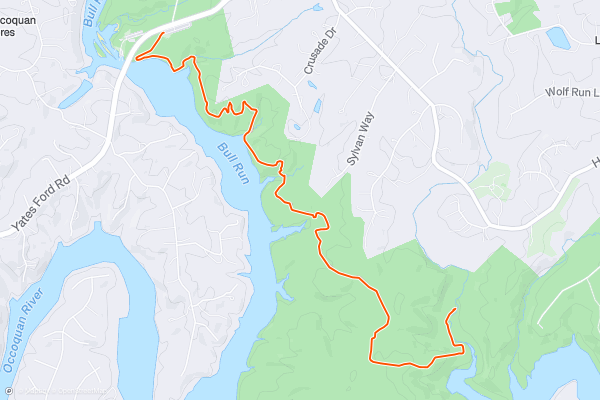
Bull Run Occoquan Trail: Out-and-Back to Coe Creek
If you are looking for a scenic hike along a beautiful river, the Bull Run Occoquan Trail is a great option. This lengthy trail follows the course of Bull Run from Bull Run Regional Park in Centreville to Fountainhead Regional Park in Fairfax Station....
19


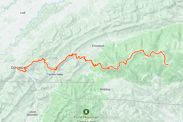
Appalachian Trail: Damascus to Massie Gap
Damascus, arguably one of the most iconic and recognized trail towns along the Appalachian Trail, serves as the southern terminus for this segment. Most thru-hikers will choose to spend a day or two exploring town and taking a break from the trail....
20


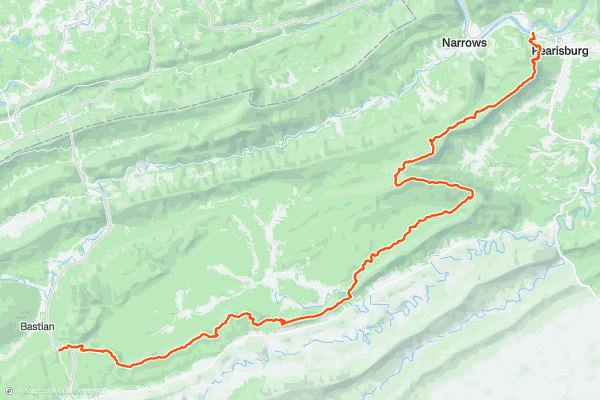
Appalachian Trail: I-77 to Pearisburg
The southern terminus for this segment is located where the trail crosses Interstate 77. The famous Brushy Mountain Outpost lies adjacent to the highway and serves as a popular place among thru-hikers to refuel after a long stretch of trail....
Page 1 of 3
Las regiones más populares para senderos de senderismo en Strava
- Acadia National Park
- Alabama
- Alaska
- Albuquerque
- Alyeska
- Angeles National Forest
- Arizona
- Arkansas
- Austin, TX
- Bay Area
- Bend
- Big Sky
- Blue Mountain Ski Area
- Boston
- Boulder, CO
- Brevard
- Bridger Bowl
- Buena Vista
- California
- Cape Cod
- Colorado
- Connecticut
- Dahlonega
- Downieville
- Ellijay
- Flagstaff
- Florida
- Georgia
- Glacier National Park (USA)
- Grand Teton National Park
- Great Smoky Mountains National Park, TN
- Hawaii
- Hurricane
- Hyalite
- Idaho
- Illinois
- Indiana
- Kansas
- Kentucky
- Lake Tahoe
- Las Vegas, NV
- Los Angeles, CA
- Maine
- Mammoth Mountain
- Marin County
- Maryland
- Massachusetts
- Maui, HI
- Michigan
- Minnesota
- Missouri
- Moab
- Montana
- Mount Rainier National Park
- Mt. Rainier National Park, WA
- Nederland
- Nevada
- New Hampshire
- New Jersey
- New Mexico
- New York
- New York, NY
- North Bridgers
- North Carolina
- North Dakota
- Oakridge
- Ohio
- Oklahoma
- Oregon
- Park City and Deer Valley
- Pennsylvania
- Phoenix, AZ
- Placitas
- Portland, OR
- Roanoke
- Salida
- Salt Lake City, UT
- San Diego, CA
- San Francisco, CA
- Santa Fe, NM
- Santa Monica Mountains
- Seattle, WA
- Sedona, AZ
- Sisters
- South Carolina
- South Dakota
- South Lake Tahoe, CA
- Stowe
- Sugarbush
- Sun Valley
- Taos
- Telluride
- Tennessee
- Texas
- Timberline Lodge Summer
- Utah
- Vermont
- Virginia
- Washington
- West Virginia
- Wind River Range
- Winter Park
- Wisconsin
- Wyoming
- Yellowstone National Park
- Yosemite National Park, CA
- Zion National Park, UT