
Idaho 中最佳的健行小徑
探索 健行小徑Idaho 中健行小徑的前 56 名
Page 1 of 3
1


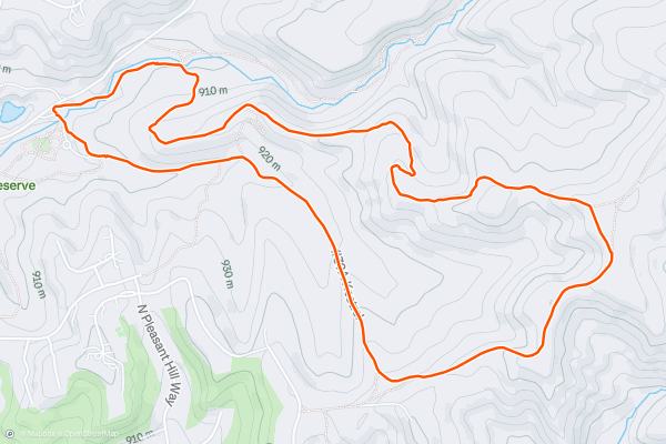
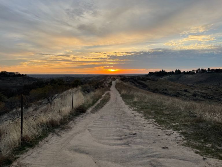
Red Cliffs and Kestrel Loop
This is one loop in the popular Hulls Gulch trail network, just outside of downtown Boise. Though it's only one possibility of many here for a short hike or jog, this loop with Red Cliffs and Kestrel trails is particularly good....
2


Lower City Creek Loop
The City Creek trail system is loved by Pocatello residents, and makes an easy outdoor destination for visitors as well. It’s an extensive network of trails in the hills, with nearly endless route options, but the perfect introductory loop can be found with Lower City Creek and Bench trails....
3
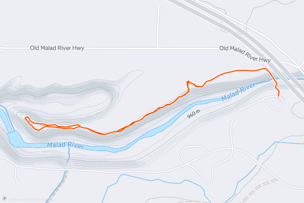
Malad Gorge
In a short detour from Interstate 84, you can see a dramatic canyon that tumbles with waterfalls. In this small unit of Thousand Springs State Park (entrance fee required) the Malad River tumbles through a tight gorge and meets a gushing spring on its way to the Snake River, which awaits out of sight downstream....
4


Cottonwood Creek Loop
Located in the Military Reserve near downtown Boise, this loop is very accessible and offers something year round for any type of hiker. It's a relatively smooth trail with very little elevation gain, and it explores a handful of different habitats in a sheltered valley....
5


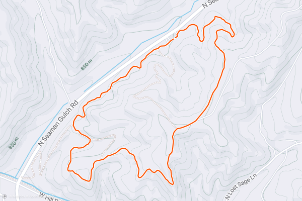
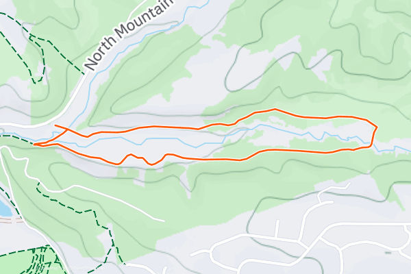
Wild Phlox and Seamans Gulch Loop
Seamans Gulch is a small trail network in the western foothills, convenient to Meridian and Eagle. Mapped here is the biggest single loop you can make, clocking in at just over two miles....
6


The Grove and Chickadee Ridge
The Grove and Chickadee Ridge are two distinct trails that can be made into a loop. You could just as well hike one or the other depending on your preference or the weather....
7


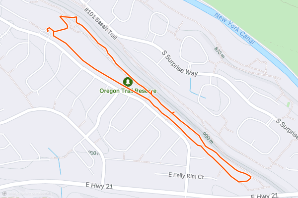
Oregon Trail Reserve: Rim Trail Loop
The Oregon Trail Reserve is a small city park that preserves a section of the famous Oregon Trail. At this spot in what is now Boise, wagons once rumbled down a stony ramp that was cut into basalt cliffs, allowing the pioneers to reach the sheltered valley of the Boise River....
8


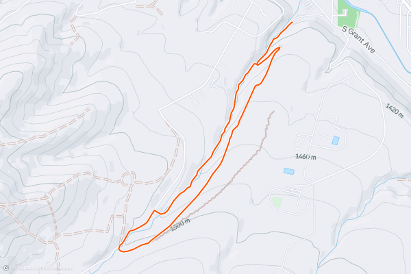
Route of the Hiawatha: East to West
The Route of the Hiawatha is renowned as the "crown jewel" of rails-to-trails adventures. According to [RideTheHiawatha.com](https://www.ridethehiawatha.com/the-trail), the trail "is 15 miles long with 10 train tunnels and 7 sky-high trestles....
9


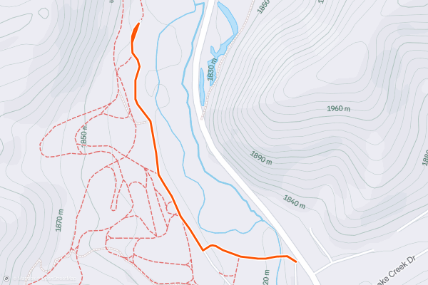
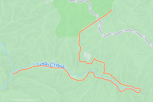
Lake Creek Trails
The Lake Creek Trailhead is along the highway just north of Ketchum, and makes a great starting point for all kinds of outings. Hikers can enjoy short and easy strolls along the river or strenuous forays into the hills....
10


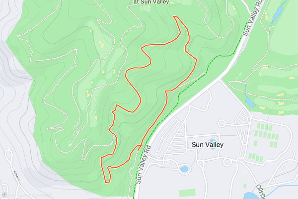
Valley View Loop
This is an easy jaunt in the vicinity of the White Clouds golf course, right across the street from Sun Valley Lodge. From the sagebrush-covered hillside, you’ll have wonderful views of the resort and its mountain backdrop....
11


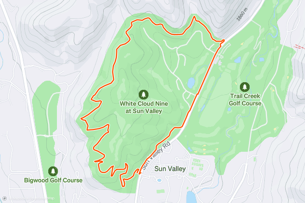
White Clouds Loop
This trail loop encircles part of the White Clouds Golf Course near Sun Valley Lodge, combining natural-surface trails and the paved Trail Creek Path. Despite the proximity to a golf course and a subdivision, it’s a trail for hikers and bikers that’s always open to the public....
12


Stack Rock Trail
Stack Rock is one of Boise’s quintessential hikes, featuring views over the Treasure Valley from high in the hills. The trail starts from Bogus Basin Road and traverses the mountainside, among a mix of forest scenery and wide open views....
13


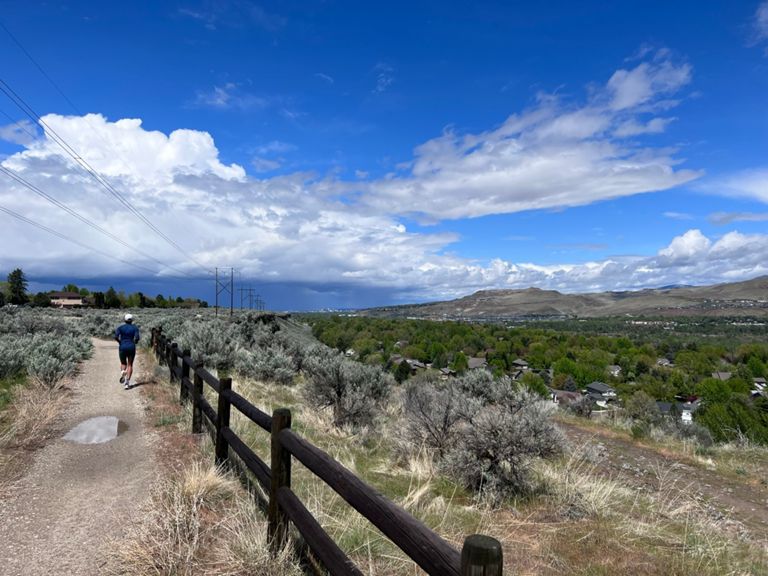
Harrison Hollow and Kemper's Ridge
Harrison Hollow is a trail network just north of downtown, popular for its convenient access plus great views. On any given day, you'll find lots of people here––hiking, walking dogs, jogging, and biking....
14


Inferno Cone
There are multiple hikes in Craters of the Moon that reach the top of cinder cones, and Inferno Cone is the shortest of them. It's a steep but smooth walk on compacted cinders to the top of this little volcano....
15


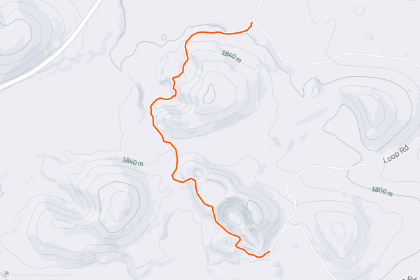
North Crater Trail
Unlike most of the park's other trails, this one does not make a loop. It's mapped here as a one-way from the southern trailhead to the northern trailhead, which can be done with a car shuttle....
16


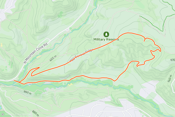
Ridge Crest and Central Ridge Loop
This is one possible loop with the many trails in Military Reserve, which is the trail system closest to downtown Boise. This particular loop makes an excellent walk or jog with some elevation gain, though it does have steep parts that will likely slow you down....
17


Adelmann Mine
The Adelmann Mine is an interesting but relatively unknown bit of Boise history. The site was mined for gold more than a century ago, and several structures plus machinery still stand, today in various stages of decay....
18


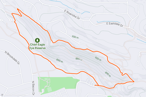
Quarry Trail and Eagle Rock Loop
Eagle Rock (also known as Castle Rock) is a volcanic outcrop above Boise’s East End, forming a dramatic balcony in the foothills overlooking the city. It’s part of an urban recreation area called Chief Eagle Eye Reserve, named after a leader of Northern Shoshone people who once lived nearby, but were forced to reservations in the 19th century....
19


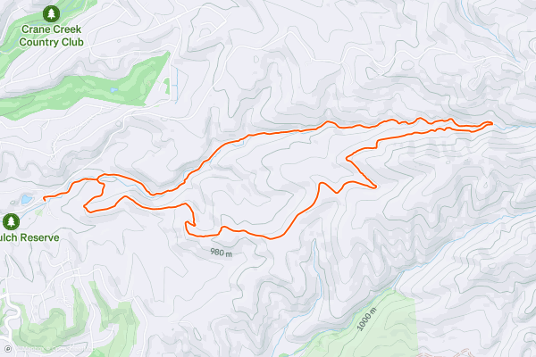
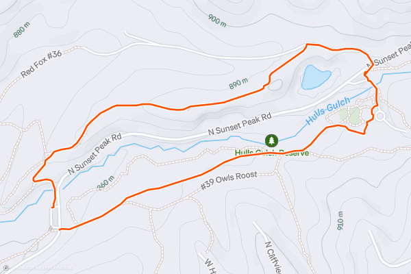
Lower Hulls Gulch and Red Cliffs Loop
Hulls Gulch is a prominent canyon in the Boise Foothills, with a creek that tumbles from the mountains right down to Camel’s Back Park. The Hulls Gulch trails are also some of the best in Boise, granting easy access and stellar views over the city....
20


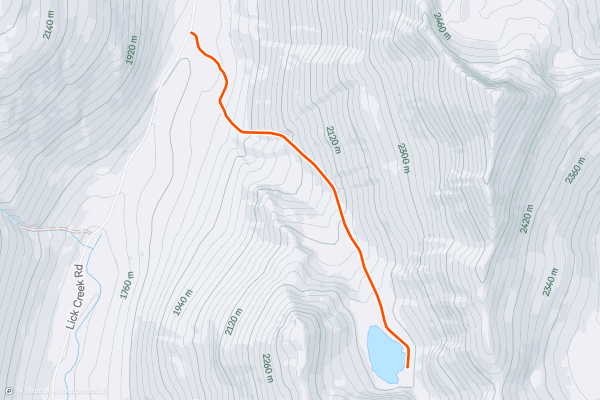
Snowslide Lake
Snowslide is a scenic lake with decent fishing, reached by a steep but quick ascent from Lick Creek Road. To get there, park at the signed Snowslide Trailhead. Find a way across the creek, then follow the obvious trail that heads uphill....
Page 1 of 3
Strava 上健行小徑的熱門區域
- Acadia National Park
- Alabama
- Alaska
- Albuquerque
- Alyeska
- Angeles National Forest
- Arizona
- Arkansas
- Austin, TX
- Bay Area
- Bend
- Big Sky
- Blue Mountain Ski Area
- Boston
- Boulder, CO
- Brevard
- Bridger Bowl
- Buena Vista
- California
- Cape Cod
- Colorado
- Connecticut
- Dahlonega
- Downieville
- Ellijay
- Flagstaff
- Florida
- Georgia
- Glacier National Park (USA)
- Grand Teton National Park
- Great Smoky Mountains National Park, TN
- Hawaii
- Hurricane
- Hyalite
- Idaho
- Illinois
- Indiana
- Kansas
- Kentucky
- Lake Tahoe
- Las Vegas, NV
- Los Angeles, CA
- Maine
- Mammoth Mountain
- Marin County
- Maryland
- Massachusetts
- Maui, HI
- Michigan
- Minnesota
- Missouri
- Moab
- Montana
- Mount Rainier National Park
- Mt. Rainier National Park, WA
- Nederland
- Nevada
- New Hampshire
- New Jersey
- New Mexico
- New York
- New York, NY
- North Bridgers
- North Carolina
- North Dakota
- Oakridge
- Ohio
- Oklahoma
- Oregon
- Park City and Deer Valley
- Pennsylvania
- Phoenix, AZ
- Placitas
- Portland, OR
- Roanoke
- Salida
- Salt Lake City, UT
- San Diego, CA
- San Francisco, CA
- Santa Fe, NM
- Santa Monica Mountains
- Seattle, WA
- Sedona, AZ
- Sisters
- South Carolina
- South Dakota
- South Lake Tahoe, CA
- Stowe
- Sugarbush
- Sun Valley
- Taos
- Telluride
- Tennessee
- Texas
- Timberline Lodge Summer
- Utah
- Vermont
- Virginia
- Washington
- West Virginia
- Wind River Range
- Winter Park
- Wisconsin
- Wyoming
- Yellowstone National Park
- Yosemite National Park, CA
- Zion National Park, UT