
Les meilleurs Chemins de randonnée à California
Explorer les Chemins de randonnée389 meilleurs chemins de randonnée à California
Page 1 of 20
1


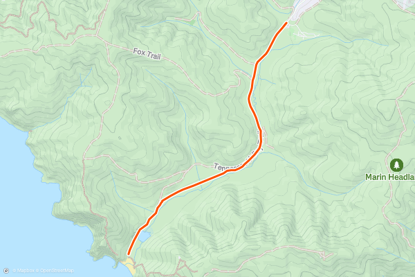
Tennessee Valley Trail
The Tennessee Valley Trail is a great hike in the Marin Headlands which takes you through a picturesque valley to an overlook of the stunning Tennessee Beach. For the most part, the trail is welcoming with good footing and plenty of space to walk side by side as a group. The trail follows an out and back route. Most consider this an easy trail which can be perfect for a full family outing. The Tennessee Valley Trail is one of the most popular hikes in the area for local Strava members
2


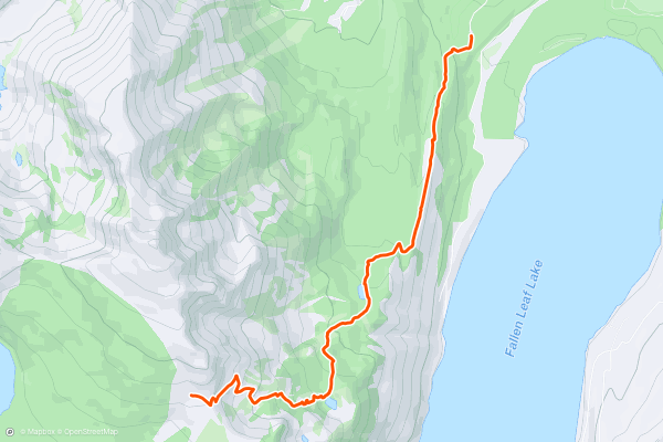
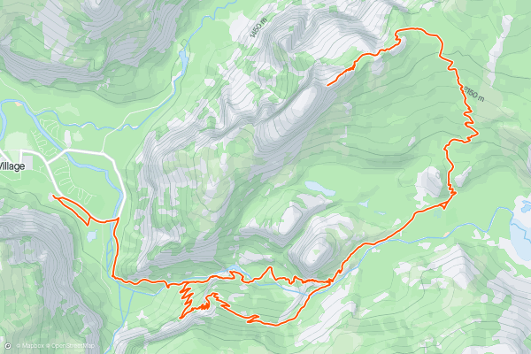
Mount Tallac Trail
The Mount Tallac Trail is a great hike that rewards you with memorable views of Lake Tahoe. The hike follows an out-and-back route, and most hikers consider it a harder trail. This hike is one of the most popular with local Strava members. Check out the photos from the community to get a sense of the breathtaking views at the summit.
3


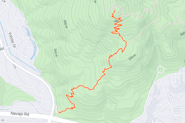
Cowles Mountain Trail
Take in the views from the highest point in San Diego on this popular and challenging hike. The Cowles Mountain Trail can be found just off Golfcrest Road in Mission Trails regional park. The trail follows an out and back route. The hike has steep overall grades throughout so be prepared for a good workout. This is one of the most popular hikes with Strava members in San Diego.
4
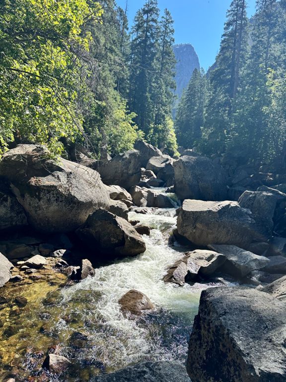


Half Dome
The Half Dome hike is one of the most challenging and rewarding hikes in the National Park System. If there’s one way to see the highlights of Yosemite National Park, this is it! You’ll begin by taking the John Muir Trail past Vernal falls, then Nevada falls. From there you’ll walk beneath Liberty Cap, through the Little Yosemite Valley to the base of Half Dome. To reach the summit of half dome, you’ll use steel cables to navigate the last 400’ of steep pitches. Many hikers bring gloves to improve their grip along this final section. This is a hard hike and should only be attempted by experienced hikers.
The cables are present during the summer (usually from just before Memorial Day to just after Columbus Day.) If you're planning on making the final push along the cabled route to the summit, you’ll need a permit. Learn how to get one here: <a href="https://www.nps.gov/yose/planyourvisit/hdpermits.htm">https://www.nps.gov/yose/planyourvisit/hdpermits.htm</a>
5


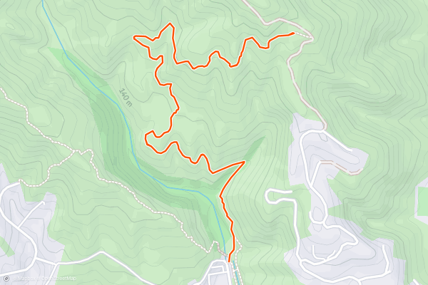
Los Leones Canyon Trail
The Los Loenes Canyon Trail is a fun hike with spectacular views of the Pacific Ocean, Santa Monica, and the Pacific Palisades. On a clear day, you might even be able to see Catalina Island shimmering in the distance. This hike follows an out and back route. The hike is on the shorter side, but steep sections near the end ensure you’ll get a good workout. This is one of the most popular hikes with Strava members in the Los Angeles area.
6


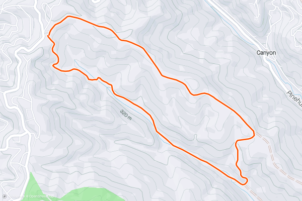
Skyline Gate Loop
The Skyline Gate Loop in Reinhardt Redwood Regional park is a stunning hike among the redwood groves of The East Bay. The trail passes a few spectacular viewpoints, but you’ll spend most of your time among the trees. Most consider this an easy trail, but the length may make it difficult depending on your hiking experience. This is one of the most popular hikes in the Bay Area with Strava members. There are also several options to extend this hike on the park's trail networks. It may be worth downloading the trail map ahead of time so you can adventure without getting lost!
7


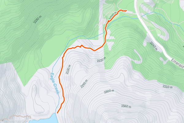
Eagle Lake Trail
The Eagle Lake Trail in South Lake Tahoe takes you from the shores of Lake Tahoe to the shores of a beautiful alpine lake. The hike follows an out-and-back route. There are several steep sections, so most consider it a difficult trail. This hike is one of the most popular in South Lake Tahoe with Strava members. Check out the photos to get a sense of the serene Eagle Lake which waits for you at the halfway point.
8


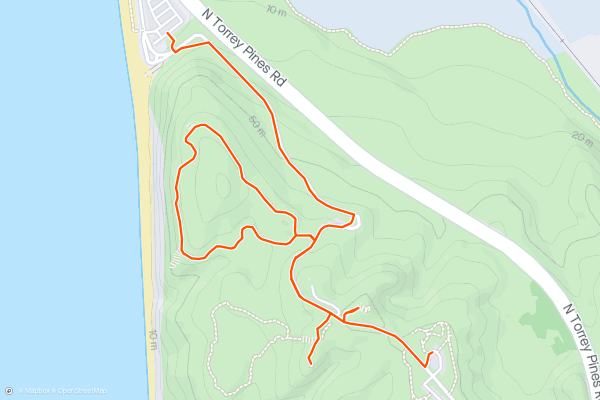
Torrey Pines
This hike around The Torrey Pines State Natural Preserve is a fun and family friendly way to explore the stunning coastal hills. You’ll briefly follow the park road, take a loop around the Guy Fleming Trail then stop by a few memorable viewpoints. Most consider this an easy route for beginner hikers, families, or those just looking for a beautiful stroll by the sea. This hike is one of the most popular trails among Strava members in San Diego.
9


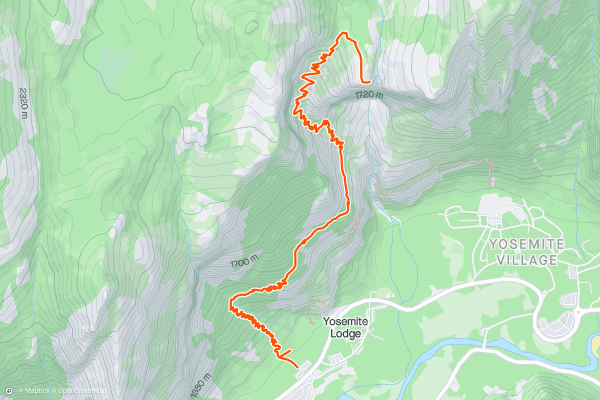
Upper Yosemite Falls Trail
Climb to the top of the tallest, and maybe most scenic, waterfall in the continental United States. The Upper Yosemite Falls trail is one of the park’s can't miss adventures. The trail begins with a series of wooded switchbacks before opening up to incredible views of Yosemite Valley. You’ll then pass Colombia Rock and a fantastic mid way view of the waterfall before tackling another set of switchbacks to the brink of the falls. This trail follows an out and back route. Because of the length, elevation gain, and occasionally treacherous surface conditions, most hikers consider this a hard hike. Upper Yosemite Falls is one of the most popular trails for Strava members visiting the park.
The waterfall is at its peak flow in the spring but may be dry at other times of year. Check out a live webcam of the falls here: <a href="https://www.nps.gov/yose/learn/photosmultimedia/webcams.htm">https://www.nps.gov/yose/learn/photosmultimedia/webcams.htm</a>
10


Glendale Peak via Riverside Trail and Hogback Trail
Glendale Peak via Riverside Trail and Hogback trail is a great hike with interesting trailside landmarks in Griffith Park. On your way to the summit’s panoramic views, you’ll pass a memorial to a prominent Sierra Club member as well as a stone staircase etched into the mountainside. This trail follows an out and back route with a loop section at the end. Because of the steep grades towards the end, most consider this a moderate trail. There are many hiking options in Griffith Park. This combination of trails is the most popular among local Strava members.
11


Dante's View
This is a wonderful “first glimpse” of Death Valley National Park. In fact, it provides sweeping views of the lowest and highest points in the park. The iconic Badwater Basin at 282 feet below sea level and 11,049-foot Telescope Peak can both be seen from this vantage point....
12


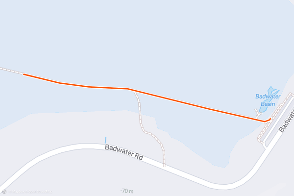
Badwater Basin
When visiting Death Valley National Park, a visit to Badwater Basin should definitely be at the top of the list! Views of the basin, with its swarms of people, are seen from other Death Valley hikes, so actually being there completes the picture....
13


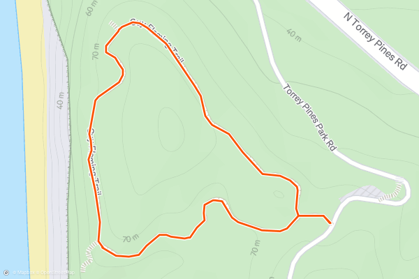
Guy Fleming Trail
Guy Fleming is one of Torrey Pines Reserve’s most popular trails. It is an easy hike and close to the front entrance, but it also happens to have great ocean views and is perhaps the reserve’s best trail for seeing the namesake Torrey pine, an endangered species....
14


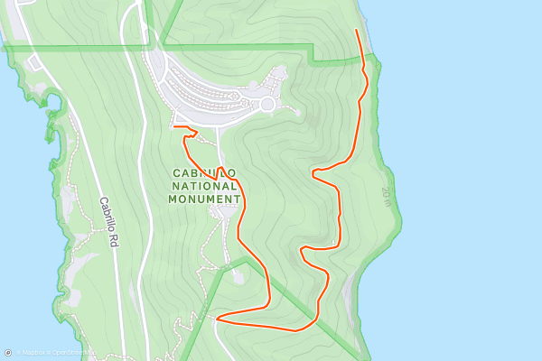
Bayside Trail
Point Loma is the south-stretching peninsula east of San Diego Bay. It’s drenched in scenery and steeped in history, both of which are preserved in Cabrillo National Monument. Named for the Spanish explorer who first sailed America’s west coast and located near the spot he first landed on its shore, the national monument honors him and protects a vestige of the natural environment he encountered here nearly 500 years ago....
15


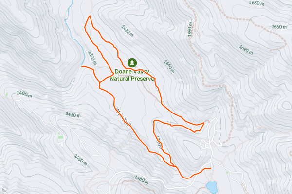
Lower Doane Valley Loop
At 5,000 feet elevation on the flanks of Palomar Mountain, you'll find an environment that is very different than the rest of San Diego County. The montane forests and meadows of Palomar receive 40 inches of precipitation a year, some of which falls as snow....
16


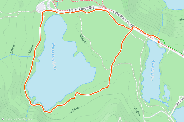
Horseshoe Lake Loop
The short loop hike around Horseshoe Lake is one of the easiest and most-accessible hikes in the Mammoth Lakes area. The Lakes Basin area, anchored by Lake Mary, is extremely popular with tourists, meaning that this easy hike is likely to be crowded....
17


Upper Rainbow Falls
The hike to Rainbow Falls follows a wide, extremely popular sandy trail. Despite being located in the John Muir Wilderness Area, this short hike is an ultra-popular tourist jaunt. When you reach the overlook for Upper Rainbow Falls, you’ll see why: Rainbow Falls is a stunning 101-foot-tall cascade in a rugged rock canyon....
18


Emerald Lake
This quick hike to Emerald Lake is easy to access and it leads to a gorgeous alpine lake, yet somehow it still stays a bit off the beaten track.
"The trail to Emerald Lake winds uphill along a beautiful creek with only about 450 feet of elevation gain,” writes [MonoCounty....
19


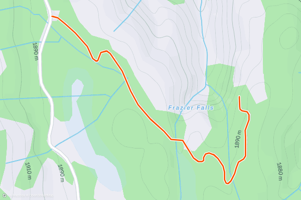
Frazier Falls
While the vast majority of the hiking destinations in the Lakes Basin are, well, lakes, Frazier Falls is a popular sight that rightfully attracts crowds of tourists. "The falls cascade down nearly 250 feet, and it is easily viewed from a platform that looks over the waterfall and the Frazier Creek Gorge downstream,” according to Aron Bosworth on [OutdoorProject....
20


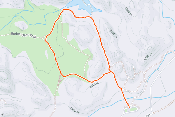
Barker Dam Trail
For such a short hike, Barker Dam Trail packs in a lot of interesting sights. You will, of course, see tall Joshua trees and giant boulder mounds, characteristic of this national park....
Page 1 of 20
Meilleures régions pour les chemins de randonnée sur Strava
- Acadia National Park
- Alabama
- Alaska
- Albuquerque
- Alyeska
- Angeles National Forest
- Arizona
- Arkansas
- Austin, TX
- Bay Area
- Bend
- Big Sky
- Blue Mountain Ski Area
- Boston
- Boulder, CO
- Brevard
- Bridger Bowl
- Buena Vista
- California
- Cape Cod
- Colorado
- Connecticut
- Dahlonega
- Downieville
- Ellijay
- Flagstaff
- Florida
- Georgia
- Glacier National Park (USA)
- Grand Teton National Park
- Great Smoky Mountains National Park, TN
- Hawaii
- Hurricane
- Hyalite
- Idaho
- Illinois
- Indiana
- Kansas
- Kentucky
- Lake Tahoe
- Las Vegas, NV
- Los Angeles, CA
- Maine
- Mammoth Mountain
- Marin County
- Maryland
- Massachusetts
- Maui, HI
- Michigan
- Minnesota
- Missouri
- Moab
- Montana
- Mount Rainier National Park
- Mt. Rainier National Park, WA
- Nederland
- Nevada
- New Hampshire
- New Jersey
- New Mexico
- New York
- New York, NY
- North Bridgers
- North Carolina
- North Dakota
- Oakridge
- Ohio
- Oklahoma
- Oregon
- Park City and Deer Valley
- Pennsylvania
- Phoenix, AZ
- Placitas
- Portland, OR
- Roanoke
- Salida
- Salt Lake City, UT
- San Diego, CA
- San Francisco, CA
- Santa Fe, NM
- Santa Monica Mountains
- Seattle, WA
- Sedona, AZ
- Sisters
- South Carolina
- South Dakota
- South Lake Tahoe, CA
- Stowe
- Sugarbush
- Sun Valley
- Taos
- Telluride
- Tennessee
- Texas
- Timberline Lodge Summer
- Utah
- Vermont
- Virginia
- Washington
- West Virginia
- Wind River Range
- Winter Park
- Wisconsin
- Wyoming
- Yellowstone National Park
- Yosemite National Park, CA
- Zion National Park, UT