
Os melhores Trilhos de caminhada em Angeles National Forest
Explorar Trilhos de caminhadaPrincipais 14 trilhos de caminhada em Angeles National Forest
1


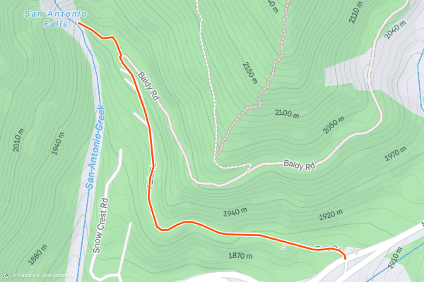
San Antonio Falls
Mount San Antonio, commonly called Mount Baldy, is the tallest of the San Gabriel Mountains north of Los Angeles. Its 10,000-foot summit collects snow in winter and meltwater streams down its rocky slopes....
2


Bridge to Nowhere
In the mountains north of Azusa, deep in the canyon of the San Gabriel River, sits a concrete arch bridge starkly out of place in its wilderness surroundings. This is the Bridge to Nowhere....
3


Switzer Falls
This hike right off the Angeles Crest Highway has excellently varied scenery, waterfalls, and swimming holes. It is one of the most popular waterfall hikes in the area. The trail starts along a bouldery creekside in the forest, climbs to sunny slopes with elevated views, then goes back down to the creek with cold pools beneath lovely cascades....
4


Hermit Falls
Hermit Falls has one of the nicest little swimming holes near LA, and it’s not hard to get to. A downhill hike through the forest leads to a granite-lined pool fed by a small waterfall....
5


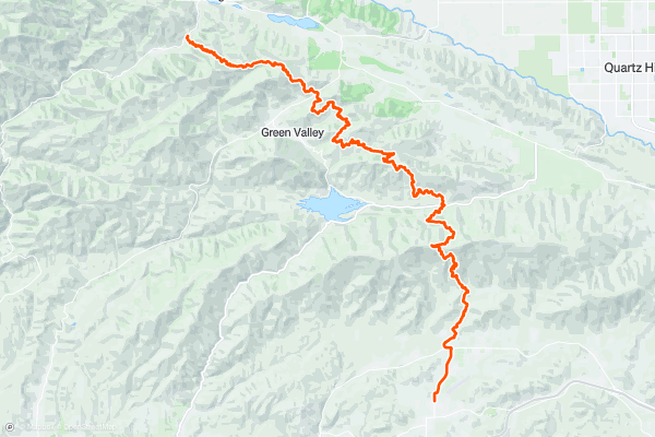
PCT: Agua Dulce to Lake Hughes
This is the start of California Section E, which is from Agua Dulce to Tehachapi Pass. It’s the section that links the Transverse Ranges of Southern California with the southern tip of the Sierra Nevada, crossing a valley of the Mojave Desert in between....
6
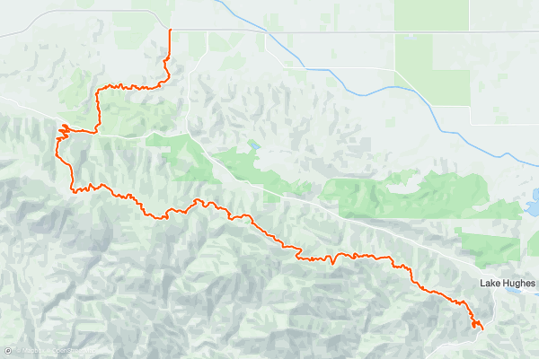
PCT: Lake Hughes to Highway 138
This is the middle segment of California Section E, which in total spans 112 miles from Agua Dulce to Tehachapi Pass. Northbound from Lake Hughes, the PCT enjoys a final hurrah of piney highlands before dropping decidedly downward, and crossing Highway 138 in a flat valley of the Mojave Desert....
7


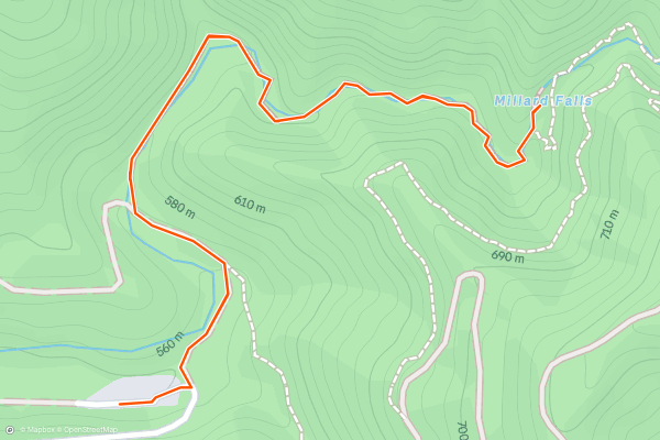
Millard Canyon Trail and Falls
Millard Canyon is part of the Angeles National Forest and is accessible via a relatively short hike from the Millard Canyon Campground. Going all the way up it to Millard Falls is highly recommended, and is only about 2 miles round trip....
8


Santa Anita Canyon - Mt. Zion Loop
**Note:** As of June 30, 2023, large sections of this loop are currently closed due to damage from the Bobcat Fire.
This hike in the San Gabriels combines some of the best scenery that LA’s mountains have to offer—dense forest, a tall waterfall, wide vistas, and a proud summit....
9


Mount Baldy Summit Loop
Mount San Antonio, at 10,064 feet, is the highest peak of the San Gabriel Mountains north of Los Angeles. It is more commonly called Mount Baldy because of its nearly treeless summit and south-facing bowl that can be seen well from LA....
10


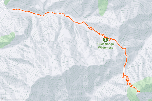
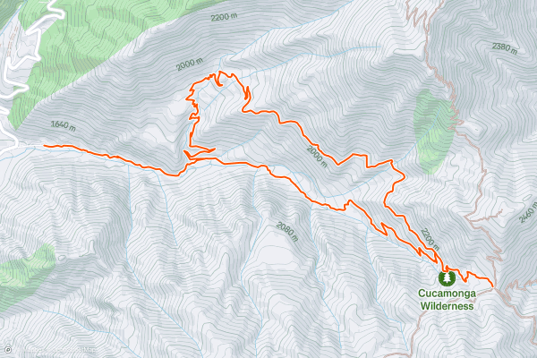
Cucamonga Peak
This hike begins in the same vicinity as popular trails on Mount Baldy but leads to a lesser-visited summit. Though Cucamonga is not as tall, its position on the southern front of the San Gabriels grants a view nearly straight down to San Bernardino Valley—a vantage not obtained from Baldy because it’s more interior in the range....
11


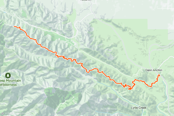
PCT: Cajon Pass to Inspiration Point
This is the first part of California Section D, which is from Cajon Pass to Agua Dulce. The segment mapped here ends at Highway 2, a common place to start/end a section hike or hitch off the trail for resupply....
12


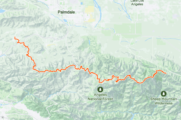
PCT: Inspiration Point to Agua Dulce
Alert: As of the time of this writing in 2021, the PCT is currently closed from Dawson Saddle trail junction to Three Point trailhead (approx. NB miles 381-403) as part of Forest Service closure following a wildfire in 2020....
13
Icehouse Canyon Trail -> Chapman Trail Loop
If you are looking for a challenging and scenic loop hike in the Cucamonga Wilderness, the Icehouse Canyon Trail to Chapman Trail Loop might be the perfect choice for you. This 8....
14


Trail Canyon Falls
Even from the name, you can get a sense of what this hike has in store: you'll walk up a canyon on a trail to find a waterfall. Simple enough, but who doesn't love a 40-foot waterfall in the bottom of a narrow gorge?! No wonder Trail Canyon Falls is such a popular hike....
Principais regiões para trilhos de caminhada no Strava
- Acadia National Park
- Alabama
- Alaska
- Albuquerque
- Alyeska
- Angeles National Forest
- Arizona
- Arkansas
- Austin, TX
- Bay Area
- Bend
- Big Sky
- Blue Mountain Ski Area
- Boston
- Boulder, CO
- Brevard
- Bridger Bowl
- Buena Vista
- California
- Cape Cod
- Colorado
- Connecticut
- Dahlonega
- Downieville
- Ellijay
- Flagstaff
- Florida
- Georgia
- Glacier National Park (USA)
- Grand Teton National Park
- Great Smoky Mountains National Park, TN
- Hawaii
- Hurricane
- Hyalite
- Idaho
- Illinois
- Indiana
- Kansas
- Kentucky
- Lake Tahoe
- Las Vegas, NV
- Los Angeles, CA
- Maine
- Mammoth Mountain
- Marin County
- Maryland
- Massachusetts
- Maui, HI
- Michigan
- Minnesota
- Missouri
- Moab
- Montana
- Mount Rainier National Park
- Mt. Rainier National Park, WA
- Nederland
- Nevada
- New Hampshire
- New Jersey
- New Mexico
- New York
- New York, NY
- North Bridgers
- North Carolina
- North Dakota
- Oakridge
- Ohio
- Oklahoma
- Oregon
- Park City and Deer Valley
- Pennsylvania
- Phoenix, AZ
- Placitas
- Portland, OR
- Roanoke
- Salida
- Salt Lake City, UT
- San Diego, CA
- San Francisco, CA
- Santa Fe, NM
- Santa Monica Mountains
- Seattle, WA
- Sedona, AZ
- Sisters
- South Carolina
- South Dakota
- South Lake Tahoe, CA
- Stowe
- Sugarbush
- Sun Valley
- Taos
- Telluride
- Tennessee
- Texas
- Timberline Lodge Summer
- Utah
- Vermont
- Virginia
- Washington
- West Virginia
- Wind River Range
- Winter Park
- Wisconsin
- Wyoming
- Yellowstone National Park
- Yosemite National Park, CA
- Zion National Park, UT