
I migliori Sentieri escursionistici a Arkansas
Esplora Sentieri escursionisticiI 18 migliori sentieri escursionistici a Arkansas
Page 1 of 1
1


Grand Promenade
The Grand Promenade is one of the must-see attractions in Hot Springs National Park and an experience everyone in the family will enjoy. Just a half-mile in length, the beautifully-kept brick walkway parallels Central Avenue and "offers views of historic downtown Hot Springs, the Arlington Lawn, the hot springs cascade, [and] quartz veins in the sandstone and tufa cliffs," according to the [NRT Database](https://www....
2
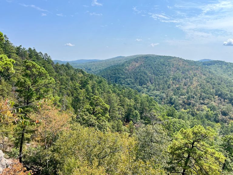


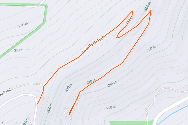
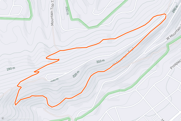
Goat Rock
Goat Rock is a classic overlook hike on North Mountain that can be accessed in many different ways. Seen here, you'll begin at the large overlook on North Mountain, not to be confused with nearby Hot Springs Mountain and home of the [historic tower](https://www....
3

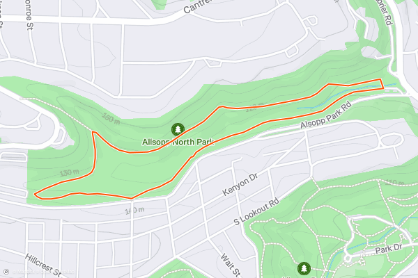
Allsopp Park North Park
Allsopp Park is the perfect setting near downtown Little Rock to enjoy a relaxing hike through the woods. North and south loops are popular among hikers, runners, and mountain bikers, and there is even trail access from nearby neighborhoods....
4


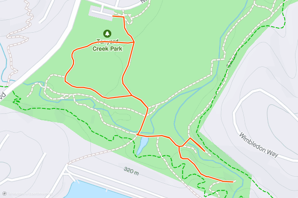
Tanyard Creek Falls
This short one-mile hike to Tanyard Creek Falls provides a fantastic dose of nature just outside of the city of Bella Vista. Easily accessible from Tanyard Creek Park, the trail begins on pavement, transitions to a wide dirt path, then narrows down to singletrack....
5
Ozark Highlands Trail: Lake Fort Smith to White Rock Recreation Area
Construction of the Ozark Highlands Trail (OHT) began in 1977, funded by the U.S. Forest Service. When funding ran out in 1981, with only a third of the planned 164-mile trail built, Tim Ernst stepped up to establish the Ozark Highlands Trail Association (OHTA) to complete construction using only volunteer labor....
6
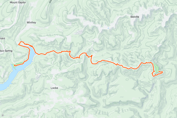
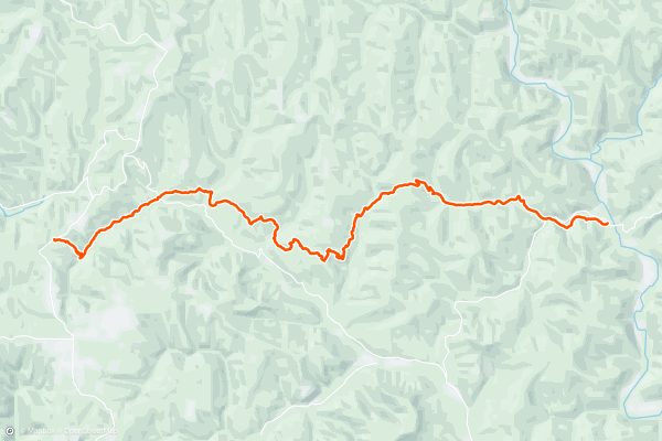
Ozark Highlands Trail: White Rock Recreation Area to Cherry Bend Trailhead / Hwy 23
After leaving the White Rock Rec Area, be sure to sign in at the visitor box installed at the intersection for the spur leading to the lookout. It's important for the park service to see that people are using the trail....
7
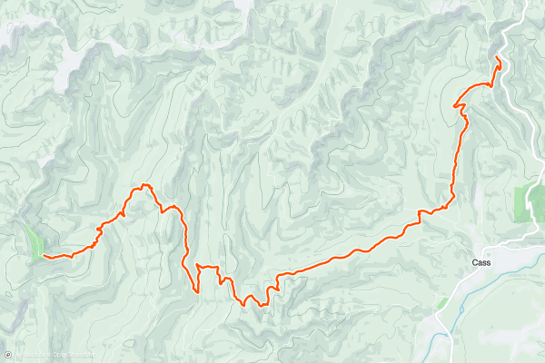
Ozark Highlands Trail: Cherry Bend Trailhead to Lick Branch Trailhead
Shortly into this section, hikers cross Highway 23, also known as the Pig Trail. Once across, it is a pleasant stroll through the Ozark Forest.
After about four miles the trail crosses Fly Gap Road....
8
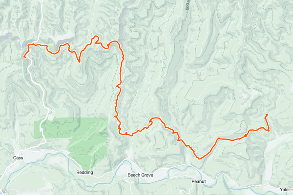
Ozark Highlands Trail: Lick Branch Trailhead to Ozone Campground on Highway 21
As with the final leg of the previous section, the start of this section winds through more beech tree forests as it flows around a hillside, littered with house size boulders, to the base of a pretty challenging climb....
9
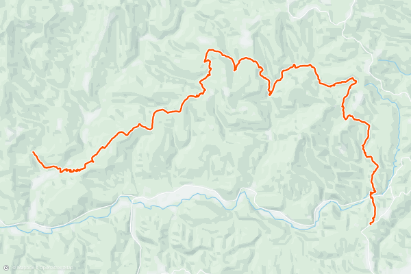
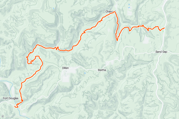
Ozark Highlands Trail: Ozone Campground on Hwy 21 to Big Piney / Ft. Douglas Trailhead
If you are hiking in on the OHT from the west, as the trail tops out there is a short spur trail to the right that will take you to the Ozone Trailhead parking, while the OHT continues straight....
10
Ozark Highlands Trail: Big Piney / Fort. Douglas Trailhead to Fairview Trailhead and Hwy 7
After exiting the Fort Douglas Trailhead parking, the OHT crosses the Big Piney River on a picturesque 1931 one-lane steel bridge. You might want to top off your water bottles in the river because in dry months it is six miles to the next reliable water....
11
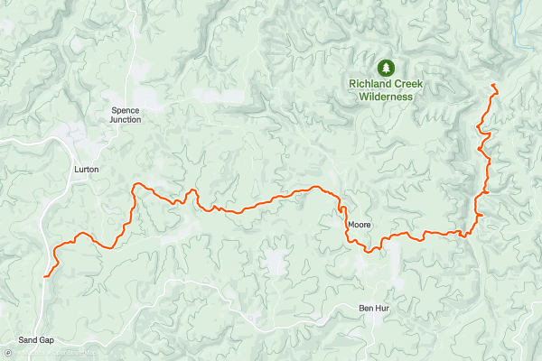
Ozark Highlands Trail: Fairview Trailhead / Hwy 7 to Richland Creek Campground
This section begins by crossing Scenic Hwy 7, a National Scenic Byway. The community of Pelsor is located about one mile south on Hwy 7. There is a Post Office there and the old 1930s Hankins General Store....
12
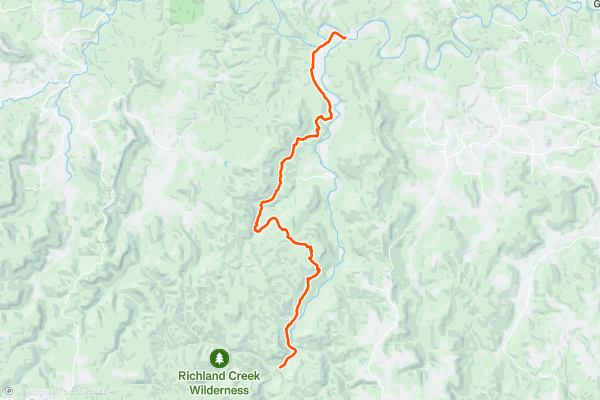
Ozark Highlands Trail: Richland Creek Campground to the Buffalo River (Woolum)
The east end of the OHT is pretty challenging to reach. Because of this inaccessibility, it doesn’t receive a lot of TLC or usage. For this reason, it is also the most difficult section to follow....
13


West Mountain Loop
West Mountain is one of the top areas to enjoy a relaxing day hike around Hot Springs NP. Several trails offer access from town and various neighborhoods, or you could drive to the top to enjoy views from the comfort of your vehicle....
14
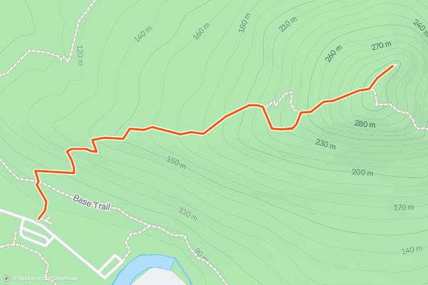
Base Trail
If summiting Pinnacle via the [western approach](https://fatmap.com/routeid/2847005/west-summit-trail-to-pinnacle-mountain) seems too daunting, or if you're just looking for a change in scenery, then the Base Trail is just for you. Less than 3 miles in length, the loop climbs a moderate ~280' and offers a more relaxing tour of the Pinnacle Mountain State Park....
15
Huckleberry Trail
The Huckleberry Trail is considered a moderate hike, with some gentle inclines and slopes. It's a accessible for beginner hikers but also an enjoyable trip for those with a bit more experience....
16


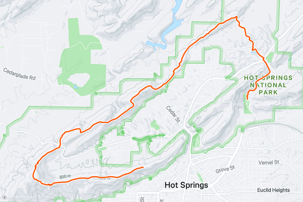
Sunset Trail
The Sunset Trail is the longest and most challenging trail in Hot Springs National Park. Beginning on West Mountain, it circles around town following a ridge bounding the park to the northwest....
17


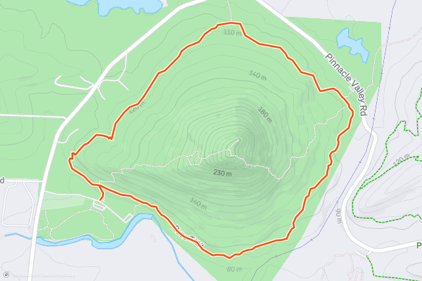
West Summit Trail to Pinnacle Mountain
As the centerpiece of its namesake state park, Pinnacle Mountain is one of the most difficult-to-reach mountaintops within hours of Little Rock. With an elevation of 1,000' above sea level, it's the second-highest point in the county and offers spectacular views of Lake Maumelle and its surroundings from its perch....
18


Upper Rattlesnake Ridge Traverse
Rattlesnake Ridge near Little Rock is a favorite area to explore for hikers and mountain bikers alike. A steady climb follows the Cliffbrake Trail to a spectacular overlook of Lake Maumelle....
Page 1 of 1
Le regioni con più sentieri escursionistici su Strava
- Acadia National Park
- Alabama
- Alaska
- Albuquerque
- Alyeska
- Angeles National Forest
- Arizona
- Arkansas
- Austin, TX
- Bay Area
- Bend
- Big Sky
- Blue Mountain Ski Area
- Boston
- Boulder, CO
- Brevard
- Bridger Bowl
- Buena Vista
- California
- Cape Cod
- Colorado
- Connecticut
- Dahlonega
- Downieville
- Ellijay
- Flagstaff
- Florida
- Georgia
- Glacier National Park (USA)
- Grand Teton National Park
- Great Smoky Mountains National Park, TN
- Hawaii
- Hurricane
- Hyalite
- Idaho
- Illinois
- Indiana
- Kansas
- Kentucky
- Lake Tahoe
- Las Vegas, NV
- Los Angeles, CA
- Maine
- Mammoth Mountain
- Marin County
- Maryland
- Massachusetts
- Maui, HI
- Michigan
- Minnesota
- Missouri
- Moab
- Montana
- Mount Rainier National Park
- Mt. Rainier National Park, WA
- Nederland
- Nevada
- New Hampshire
- New Jersey
- New Mexico
- New York
- New York, NY
- North Bridgers
- North Carolina
- North Dakota
- Oakridge
- Ohio
- Oklahoma
- Oregon
- Park City and Deer Valley
- Pennsylvania
- Phoenix, AZ
- Placitas
- Portland, OR
- Roanoke
- Salida
- Salt Lake City, UT
- San Diego, CA
- San Francisco, CA
- Santa Fe, NM
- Santa Monica Mountains
- Seattle, WA
- Sedona, AZ
- Sisters
- South Carolina
- South Dakota
- South Lake Tahoe, CA
- Stowe
- Sugarbush
- Sun Valley
- Taos
- Telluride
- Tennessee
- Texas
- Timberline Lodge Summer
- Utah
- Vermont
- Virginia
- Washington
- West Virginia
- Wind River Range
- Winter Park
- Wisconsin
- Wyoming
- Yellowstone National Park
- Yosemite National Park, CA
- Zion National Park, UT